
Overview
You will learn
- How to subscribe to the SAP HANA Spatial Service in the SAP Business Technology Platform
- How to use the REST API for geocoding, mapping, and routing services
- How to call these services from a sample program


Prerequisites
Prerequisites
- Access to an SAP Business Technology Platform account with the ability to add the SAP HANA Spatial Service
- A tool such as the REST Client extension for Visual Studio Code enabling the calling of a REST API
- A development tool such as Visual Studio Code or the SAP Business Application Studio to create Python and Node.js applications
Steps
Intro
SAP HANA Spatial Services provide a unified interface to spatial services that support various back-end service providers such as Here and Esri. These services can be accessed through a REST API and provide support for geocoding, routing, and mapping. Details of these REST APIs can also be found in the SAP API Business Hub.

The video Access HANA Spatial Services APIs Using Visual Studio Code provides a demonstration of accessing the three APIs.
Full details on the setup can be found at SAP HANA Spatial Services Onboarding Guide. The following is a brief summary of the required steps.
Regions where SAP HANA Spatial Services are available can be found in the SAP Discovery Center.
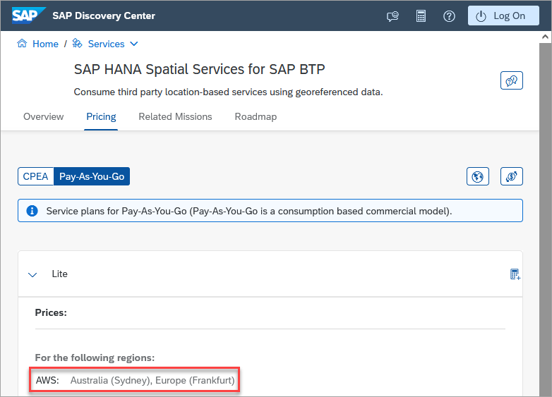
service availability After creating a subaccount in one of the regions that offers the SAP HANA Spatial Services, add the entitlement.
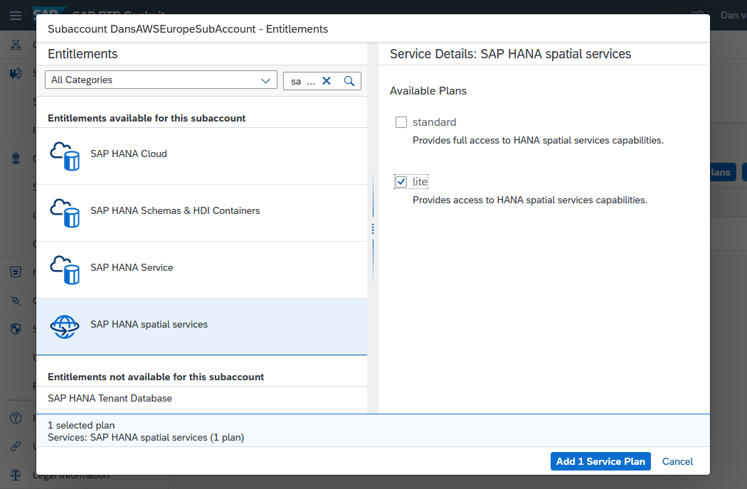
add the entitlement Additional details on adding entitlements can be found at Add a New Entitlement to Your Subaccount.
Create a service instance.
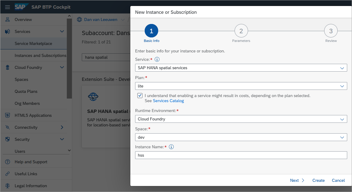
create the service Add a service key to the service which provides the URL and credentials to access the service.
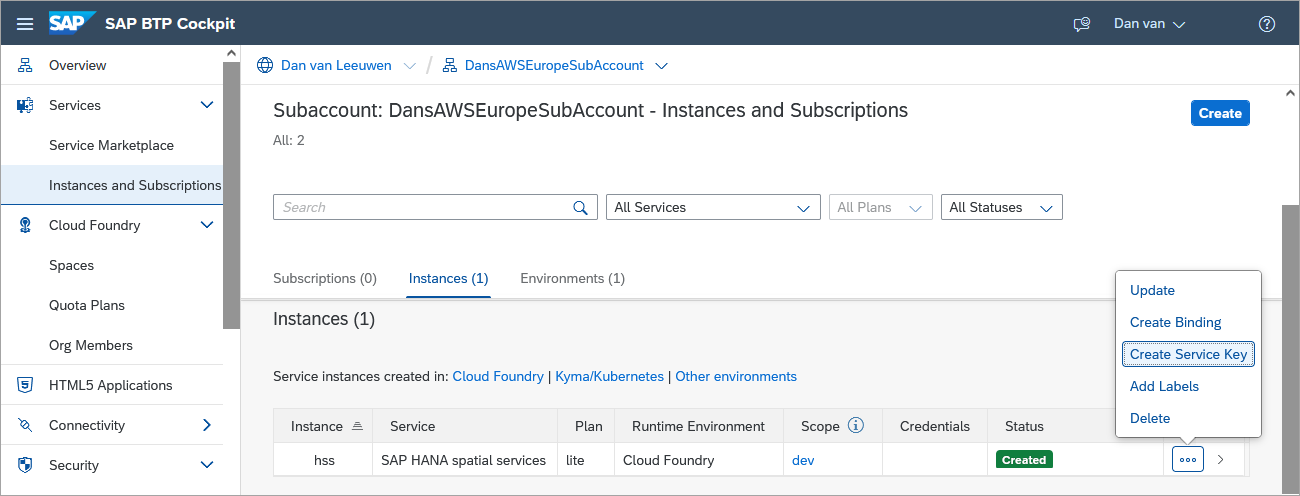
add a service key When creating a service key, a JSON file or parameters section is not needed and can be left empty.
There are multiple tools that enable making calls to a REST API such as Postman, browser extensions, libraries in programming languages such as requests in Python or https in Node.js. Feel free to use the tool of your choice. This tutorial will be using the REST Client extension for Visual Studio Code. The following content demonstrates how to make a REST API call in general.
If required, download Visual Studio Code.
Create a folder and a text file that will contain REST API calls and open the file with Visual Studio Code.
Shellmkdir %HOMEPATH%\HSSTutorial cd %HOMEPATH%\HSSTutorial code HSS.httpPaste the following into the opened file and save it.
HTTP#Example REST API call #From https://stackoverflow.com/questions/5725430/http-test-server-accepting-get-post-requests and GET https://httpbin.org/get?firstname=Bob&lastname=Smith ### #Example REST API call #From https://www.twilio.com/blog/2017/08/http-requests-in-node-js.html GET https://api.nasa.gov/planetary/apod?api_key=DEMO_KEY ### #Pet Store #From https://petstore.swagger.io/#/pet/findPetsByStatus GET https://petstore.swagger.io/v2/pet/findByStatus?status=available ###The # is used as a single line comment character and ### is used to separate REST API calls.
Add the REST Client extension from Marketplace after opening the extensions view.

Install Rest client Try calling the sample REST APIs by clicking on the blue text
Send Request.
send request The results should appear in another pane. An example result is shown below.

sample RESP API Call Notice that the URL includes the URL parameters
firstnameandlastname. The first parameter is indicated with a?, while the subsequent parameters are indicated by an&.
The following steps are required to create a bearer token that will be used in subsequent steps that make REST API calls. The bearer token is generated by a login request and can be understood as “give access to the bearer of this token”. Additional details can be found at User Account and Authorization Service for Cloud Foundry.
In the SAP BTP Cockpit, navigate to the previously created SAP HANA Spatial Services instance and select the service key.

Access the service key View the created service key. The next step will require the
uri,uaa.url,clientid, andclientsecretvalues.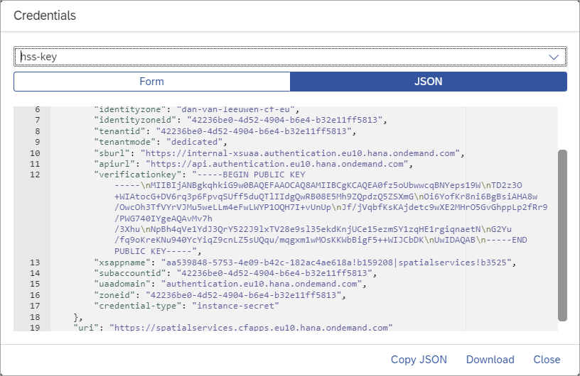
Examine the service key Replace the contents of HSS.http file with the contents below. Highlighted values are to be updated with details from your service key.
HTTP[4,#REST Client variables ------------------- #From the uri, last field in the service key @uri = @oauth = oauth/token?grant_type=client_credentials #From the uaa.url field. @uaa_url = #From the clientid field. @clientid = #From the clientsecret field. @clientsecret = #Generated by the request bearer token call. Copy the access_token value from the result without the quotes @bearer = #Authorization REST API call -------------------- #Request Bearer Token GET {{uaa_url}}/{{oauth}} Authorization: Basic {{clientid}}:{{clientsecret}} ###Execute the Request Bearer Token call using the Send Request link. Copy the returned
access_tokenvalue to the bearer variable on line 17 of the file HSS.http.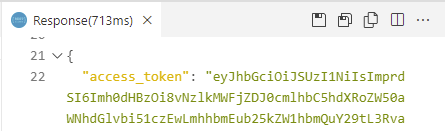
start of the access_token to be Copied
The following instructions will demonstrate how to provide one or more addresses and generate longitude and latitude values for each address. Further details are available at Geocoding API v1.
Add the following to the bottom of HSS.http.
HTTP#Geocoding example POST {{uri}}/geocoding/v1/geocode Authorization: Bearer {{bearer}} content-type: application/json { "credentials": { "provider": "Here", "api_key": "SAP-KEY" }, "addresses": [ "445 Wes Graham Way, Waterloo", "Seagram Drive, Waterloo" ] } ###Send the request to use the Here provider to geocode the provided address for the SAP Waterloo Labs office.

Result of request to geocode A returned value can be verified by entering it into Google Maps as shown below.

verifying the result An example of making the REST API call in a Python program is shown below.
Install the requests module and create and edit a Python file.
Shellpip install requests code geocode.pyCopy the below code into geocode.py. Highlighted values are to be updated with details from your service key. Sensitive values could alternatively be read from environment variables.
Python[6,#Import your dependencies import requests, os, json #request a bearer token #update uri, oauth_url, and auth values to match values from your service key uri = "" oauth_url = "" + "/oauth/token?grant_type=client_credentials" #Fill in clientID and clientsecret values below auth = ("","") #A better practice is to access credential values from environment variables #auth = os.environ.get('clientid'), os.environ.get('clientsecret')) response = requests.post(oauth_url, auth=auth) bearer_token = json.loads(response.text) #print('Auth token: ', bearer_token) #call the geocode REST API request_headers = { 'accept': 'application/json', 'content-type': 'application/json', 'authorization': 'Bearer '+ bearer_token.get('access_token') } json_data = { "credentials": { "provider": "Here", "api_key": "SAP-KEY" }, "addresses": [ "445 Wes Graham Way, Waterloo", "Seagram Drive, Waterloo" ]} response = requests.post(uri + "/geocoding/v1/geocode", headers=request_headers, json=json_data) geocode_result = json.loads(response.text) print(json.dumps(geocode_result, indent=2))Shellpython geocode.py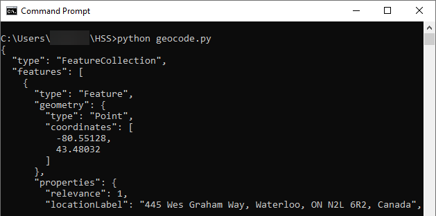
calling geocode API from Python
The following instructions will demonstrate how to take two addresses and generate a set of directions between the two addresses. Further details are available at Routing API v1.
Add the following to the bottom of
HSS.http.HTTP#Routing example #geojson result can be viewed on a map at https://geojson.io/# POST {{uri}}/routing/v1/route Authorization: Bearer {{bearer}} content-type: application/json { "credentials": { "provider": "Here", "api_key": "SAP-KEY" }, "waypoints": { "type": "MultiPoint", "coordinates": [ [ -80.55128, 43.48032 ], [ -80.53434, 43.46942 ] ] }, "vehicleType": "pedestrian" } ###Send the request to use the Here provider to get route details between the two provided addresses. The following is the returned
geojsonresponse.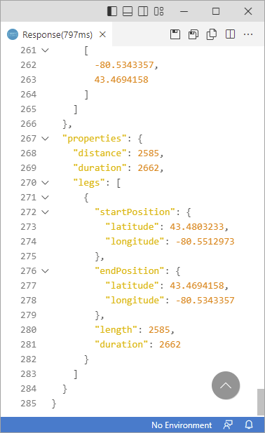
Result of request for routing A few of the returned values are explained below:
coordinatesis an array of the points that show the route selected.lengthis the distance of the route in meters.durationis the time the route will take in seconds.
In the above example, the route is 2 and 1/2 Kilometers and should take 44 minutes to walk.
The returned result can also be shown on a map that accepts
geojsonresults as shown below.
route shown on a map An example of making the REST API call in a Node.js application is shown below.
Initialize a Node project, install node-fetch and create and edit a JavaScript file.
Shellnpm init -y npm install node-fetch@2 code route.jsCopy the below code into route.js. Highlighted values are to be updated with details from your service key. Sensitive values could alternatively be read from environment variables.
JavaScript[3,const fetch = require('node-fetch'); const oauth_url = "" + "/oauth/token?grant_type=client_credentials"; const uri = ""; //Fill in clientID and clientsecret values below const auth = "Basic " + Buffer.from("" + ":" + "").toString('base64'); //const auth = "Basic " + Buffer.from(process.env.clientid + ":" + process.env.clientsecret).toString('base64'); //Note, on Windows, precede | with ^| in the clientid when setting the environment variable const outh_headers = { "Content-Type": "application/json", "Authorization": auth } var request_headers = { "Content-Type": "application/json", "authorization": "Bearer " } const json_data = { "credentials": { "provider": "Here", "api_key": "SAP-KEY" }, "waypoints": { "type": "MultiPoint", "coordinates": [ [ -80.55128, 43.48032 ], [ -80.53434, 43.46942 ] ] }, "vehicleType": "pedestrian" } //Get the bearer token fetch(oauth_url, { method: 'GET', headers: outh_headers }) .then((res) => { return res.json() }) .then((auth_result) => { //Add the bearer token to the authorization header request_headers.authorization = request_headers.authorization + auth_result.access_token; //make a routing request fetch(uri + "/routing/v1/route", { method: 'POST', headers: request_headers, body: JSON.stringify(json_data) }) .then((res) => { return res.json() }) .then((routing_result) => { console.log(JSON.stringify(routing_result, null, 2)); }); });
routing call from Node.js
The following instructions will demonstrate how to use the mapping service to return a map tile. Further details are available at Mapping API 1.0.
Add the following to the bottom of
HSS.http.HTTP#Mapping examples GET {{uri}}/mapping/v1/here/tiles/maptile/newest/normal.day/4/8/5/256/png Authorization: Bearer {{bearer}} ### GET {{uri}}/mapping/v1/here/tiles/maptile/newest/normal.day/4/4/6/512/png Authorization: Bearer {{bearer}} ###The parameters used in this example are explained below:
providerin this example is Here.zoom/column/rowthese values are further explained at Here Map Tile documentation.sizeis the pixel size of the map tile such as 256 or 512.
Send the requests to use the Here provider to return map tiles.

Mapping result A mapping control such as the SAP Fiori GeoMap can be used to display multiple map tiles and provide items on the map. The video Using the SAP HANA Spatial Services Mapping API in a Fiori App provides a demonstration of this.
Congratulations! You have now used the HANA Spatial Services to perform geocoding, routing, and mapping. Upcoming features can be seen on the SAP Road Map Explorer.
Resources
Discussion
Share feedback on this tutorial or join the conversation in SAP Community.